1162. 地图分析
你现在手里有一份大小为 N x N 的「地图」(网格) grid,上面的每个「区域」(单元格)都用 0 和 1 标记好了。其中 0 代表海洋,1 代表陆地,请你找出一个海洋区域,这个海洋区域到离它最近的陆地区域的距离是最大的。
我们这里说的距离是「曼哈顿距离」( Manhattan Distance):(x0, y0) 和 (x1, y1) 这两个区域之间的距离是 |x0 - x1| + |y0 - y1| 。
如果我们的地图上只有陆地或者海洋,请返回 -1。
示例1:
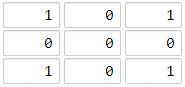
输入:[[1,0,1],[0,0,0],[1,0,1]]
输出:2
解释:
海洋区域 (1, 1) 和所有陆地区域之间的距离都达到最大,最大距离为 2。
示例 2:
输入:[[1,0,0],[0,0,0],[0,0,0]]
输出:4
解释:
海洋区域 (2, 2) 和所有陆地区域之间的距离都达到最大,最大距离为 4。
提示:
1 <= grid.length == grid[0].length <= 100grid[i][j] 不是 0 就是 1
思路
筛选到所有陆地,逐个向外(四个方向)遍历一次,并将遍历到的海洋标记为已经遍历,记录下遍历距离,最后遍历到的海洋即是最远位置的,返回此时距离.
代码
 1
 2
 3
 4
 5
 6
 7
 8
 9
10
11
12
13
14
15
16
17
18
19
20
21
22
23
24
25
26
27
28
29
30
31
32
33
34
| func maxDistance(grid [][]int) int {
land := make([][]int, 0)
length := len(grid)
// 拓展方向
dx := []int{1, -1, 0, 0}
dy := []int{0, 0, 1, -1}
// 记录陆地坐标
for i := range grid {
for i2 := range grid[i] {
if grid[i][i2] == 1 {
land = append(land, []int{i, i2})
}
}
}
// 没有陆地或者没有海洋返回-1
if len(land) == 0 || len(land) == length*length {
return -1
}
i := 0
for ; i < len(land); i++ {
x, y := land[i][0], land[i][1]
for j := 0; j < 4; j++ {
newX, newY := x+dx[j], y+dy[j]
if newX < 0 || newY < 0 || newX >= length || newY >= length || grid[newX][newY] != 0 {
continue
}
grid[newX][newY] = grid[x][y] + 1
land = append(land, []int{newX, newY})
}
}
i--
x, y := land[i][0], land[i][1]
return grid[x][y] - 1
}
|